Explore Greece Plan your trips Take your trips with you Experience & visit places in 360 images and videos
Let us guide you!
Are you travelling in Greece but don't know where to start? Do you want to plan your trip?
What is Dimoleon
Dimoleon offers a trip planner and mobile argumentative application that will guide you every where around your trips
Our picks
Most liked places
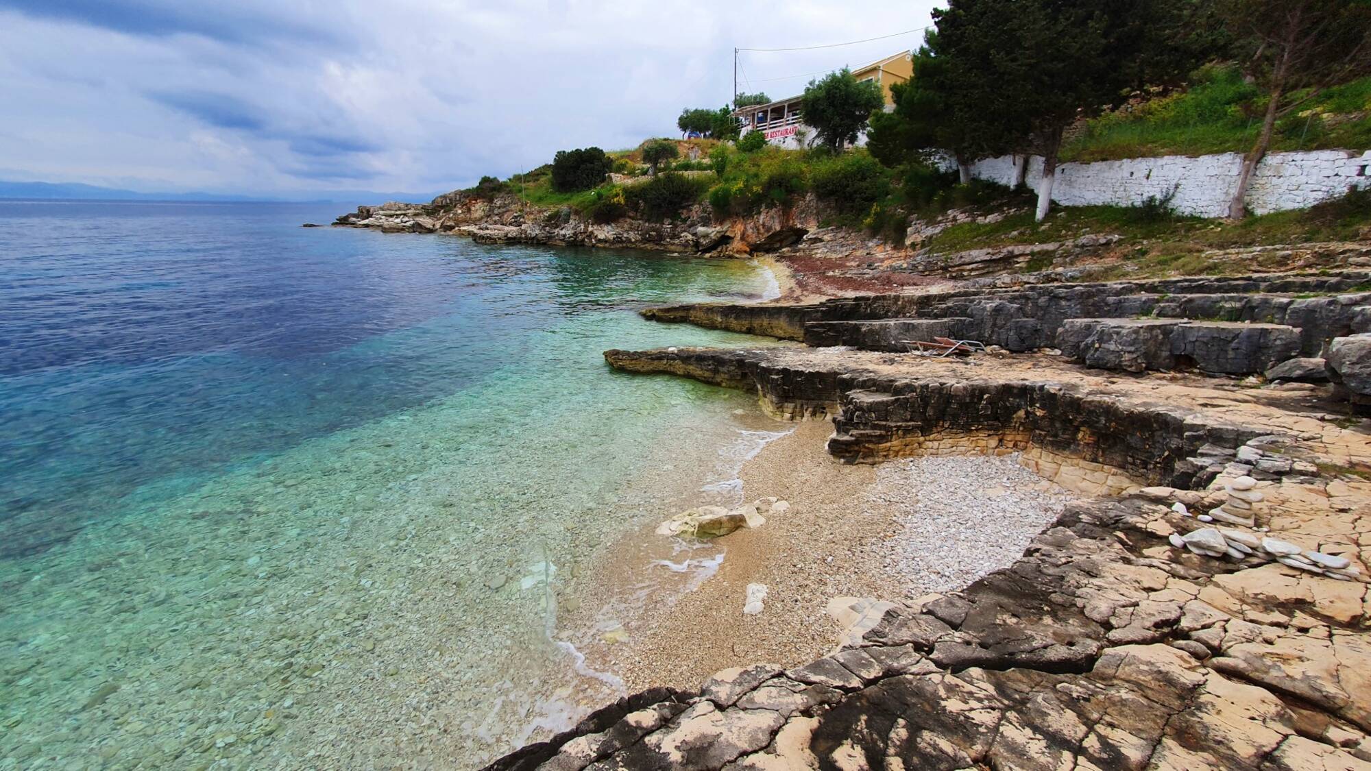
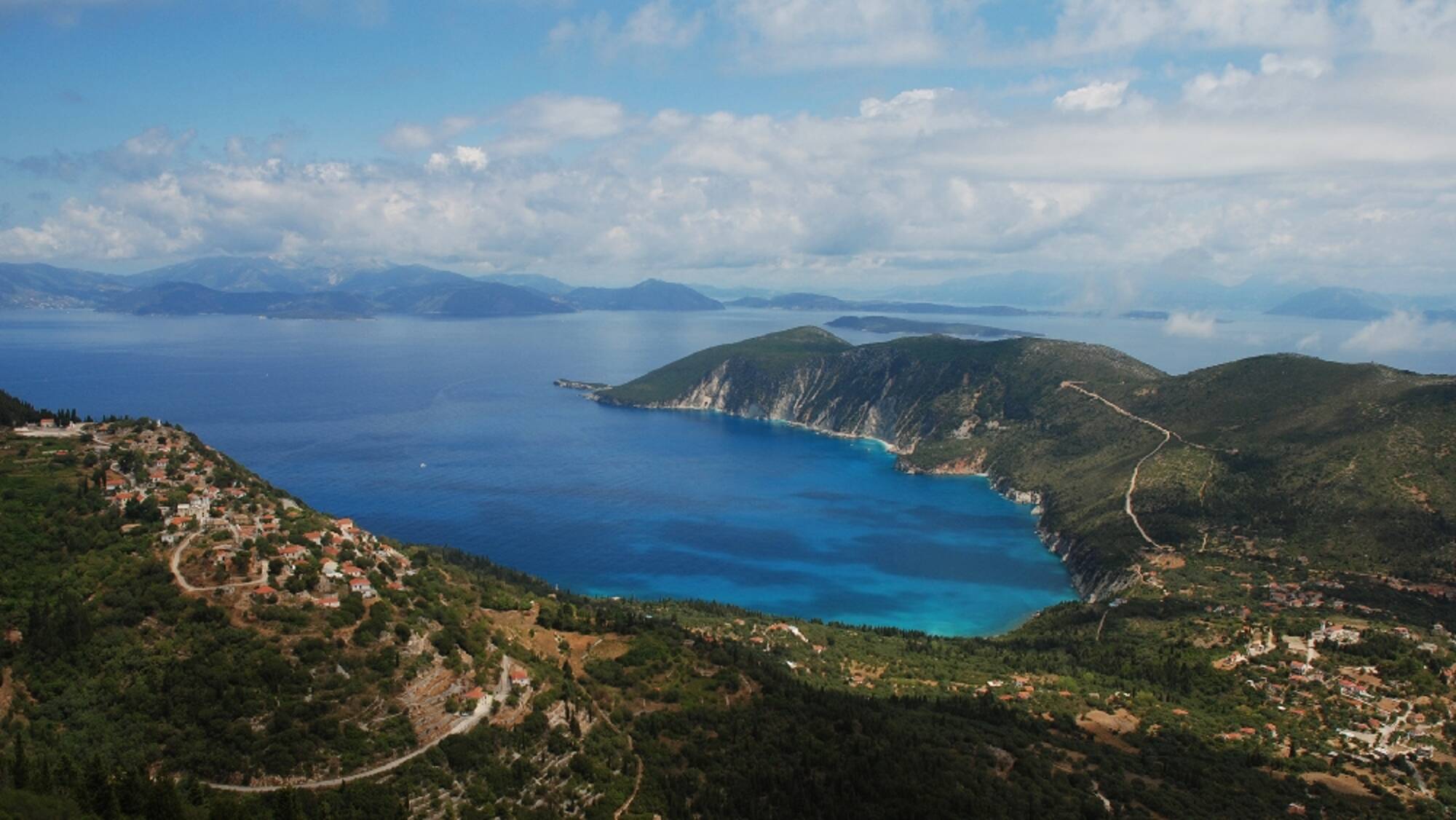
Plakes Beach
At the southern end of the settlement of Gaios, there is the small beach Plakes, with pebbles and rocky slabs.
Place
Paxi
About
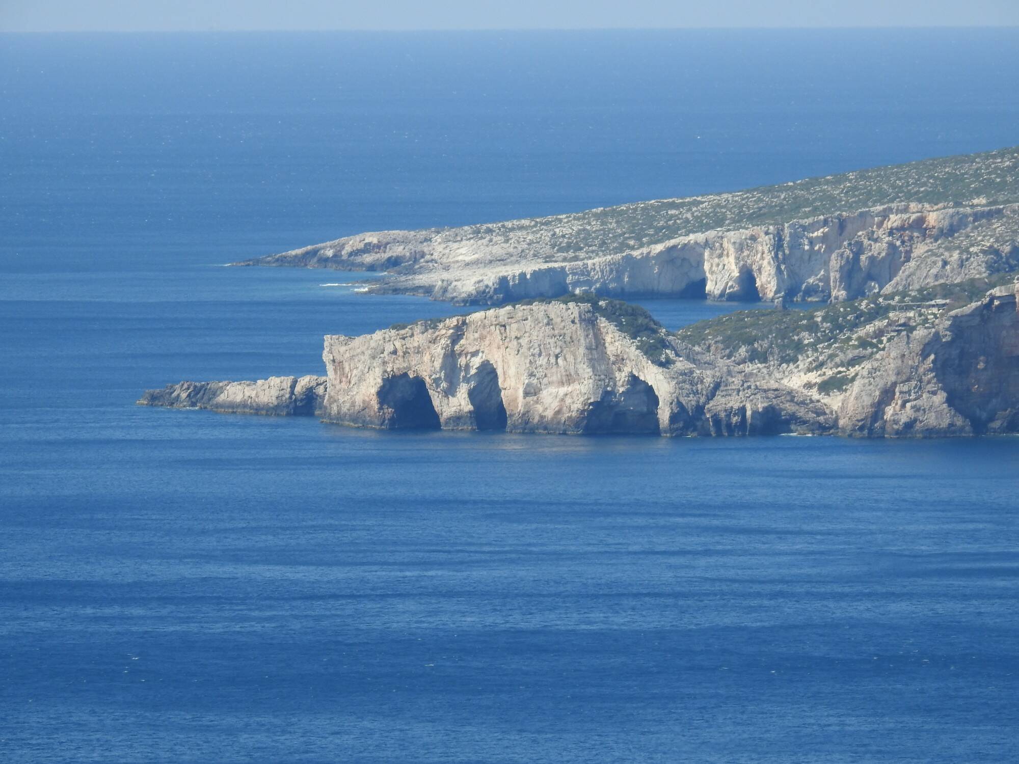
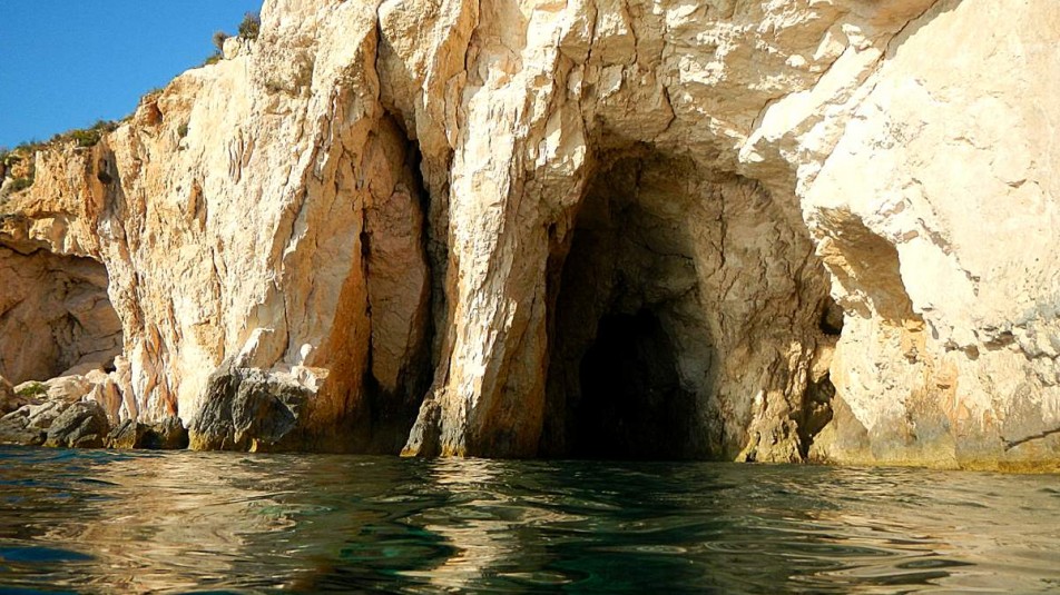
Blue caves of Agalas
The west coast and the blue caves have been included in the Natura 2000 network of protected areas. The geological formations with the peculiar sea caves in which the water has impressive blue reflections. Many sea excursions take place during the summer months to reach the natural geomorphorphological sights of the island.
Place
Zakynthos
Agios Sostis Beach
This is a narrow sandy beach with pebbles in some places, the sea is shallow and crystal clear. The beach is part of the Gulf of Laganas and so is protected by the National Marine Park of Zakynthos. Sunbeds and umbrellas are available to rent and on the road up off the beach there are bars, restaurants and mini markets. From this beach you can enjoy the view over to Marathonisi and Cameo. The small island that you see linked to the beach is a club during the summer months. From the beach you can rent a boat for the day and visit Marathonisi and see the other natural attractions of the Gulf. It is an Ideal choice for peace and quite and families. The area is well developed and you can combine your days swimming with eating out.
Place
About
Porto Vromi
Porto Vromi is typical for its geological formations, crystal clear waters and caves to be explored. From this natural harbor boats are departing for the Shipwreck and the western caves. It is part of the Natura 2000 network along the west and northeast coasts of the island.
Place
About
.jpeg)
Snt Lion
The first inhabitants were liberated from the region of Catania (Liberi da Catania), [eastern Sicily, almost opposite Zakynthos]. When they landed in Zakynthos [then under Venetian Rule] they were ordered by the Venetians to head for the great mountain (the Brahion). They climbed there alone (without an escort) and settled in the middle of the mountain range, where they built their houses and a church dedicated to Saint Leo, the bishop and later patron saint of Catania.
The village was not given an 'official' name from the beginning, since it was established without the presence of a Venetian and without the drawing up of a land register (as can be seen from the events that followed).
The Venetians initially noted that the Liberi da Catania had been sent to the area, designating the site, and when they later intervened to sort things out, they accepted the name of Saint Leo, in honour of the settlers. It is also indicative that these settlers took and retained the double surname Liberi da Catania from their new legal status of liberation and their place of origin, since before, as serfs, they had no surnames.
As predicted, the Venetians sent former serfs of Catania to the mountains and did not count (from the beginning) the extent of their jurisdiction. In the following period they continued to send settlers to the area. And the most important expedition seems to have been the large group from the Messinian village of Basta (Vasta), after the fall of the castle of Koroni in 1534.
On a nearby hill, there is the church of the village's patron saint, Saint Leontas, dedicated to the homonymous Bishop of Sicily (San Leone Vescovo di Catania). It is located at an altitude of about 350 metres, at the foot of Mount Brachionas.
Around the village there was a fairly large pine forest, which after a large fire on 26 August 2011 was burnt to the ground. The fire reached very close to a residential area without causing any other damage. The forest landscape has regenerated due to the high soil moisture.
Place
About
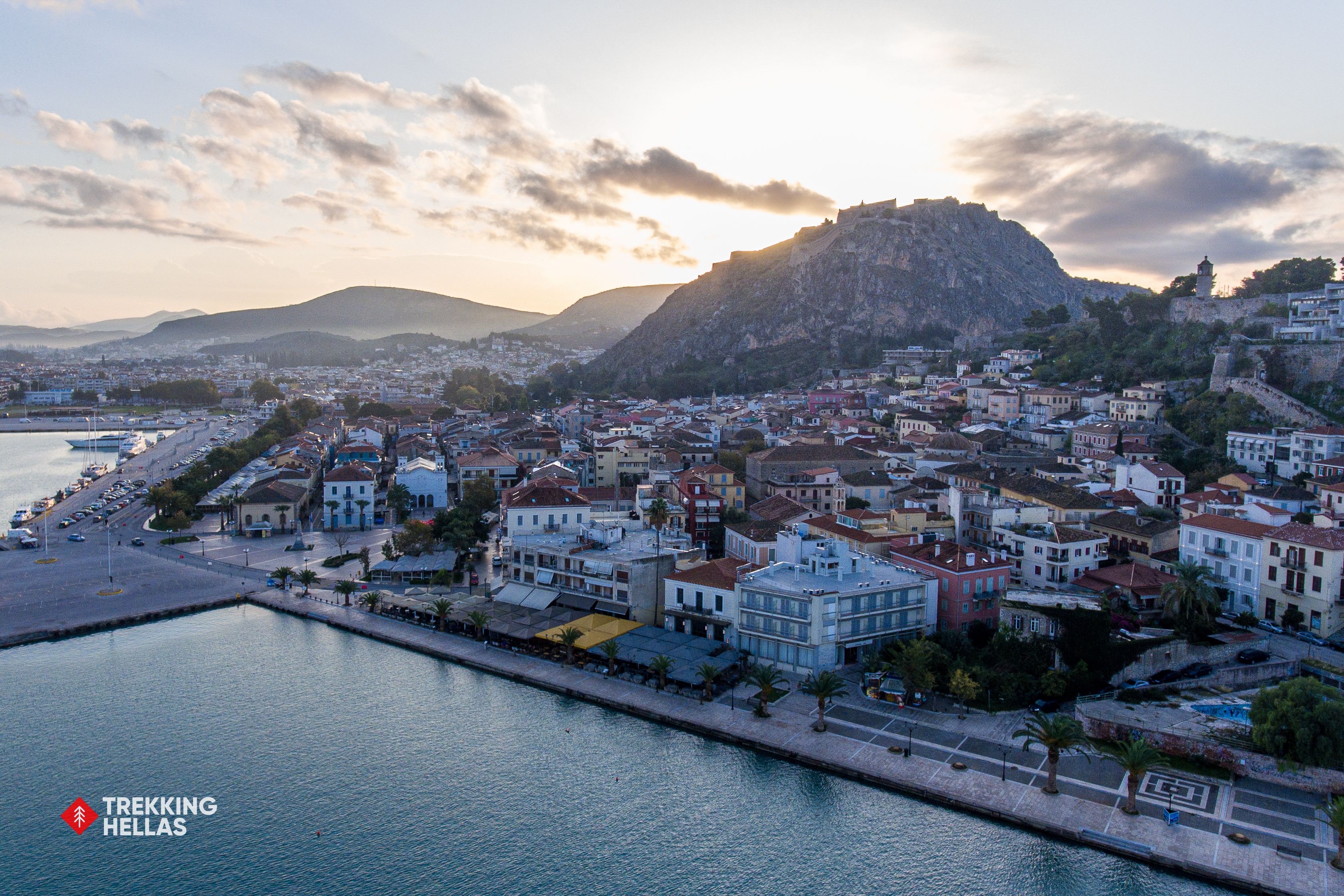
Nafplion marina
We leave behind the busy city of Athens and head to Nafplio. Nafplio, considered one of the most beautiful cities in Greece, was the country's first capital after independence and an important port since the Bronze Age. Take time to enjoy a stroll through the alleys of the town and climb the 999 steps to the legendary Palamidi Fortress to enjoy the panoramic view.
Place
Argolis,Nafplion
About
Outdoor Activities
With so much to do and see in Greece, the opportunities are truly endless. Check any activities that you might like and plun your trip.
The Round of Gyra
The Tour of Gyra: Lefkada - Agios Ioannis Beach - Gyra Beach - Amoglossa - Lefkada
The walker’s orientation and safety is solely their responsibility. The present report, the relevant tracks (gpx) and the rest of the informational material are just supplementary. The proper equipment is necessary, depending on the weather conditions and the nature of the route.
Route’s type: circular
Route’s duration: 2 hours and 15 minutes
Route’s length: 8,200 meters
Level of difficulty: easy
Suggested season: All seasons, if weather conditions permit it. In summer, you should avoid the midday hours because there are no shady places on most of the route
The route
The route involves the town of Lefkada and especially the large lagoon that covers most of northern Lefkada: the Palionis lagoon. It is recommended to do it in the afternoon, in order to catch the sunset, which is magnificent.
The route starts from the wooden footbridge at the roundabout at the entrance of Lefkada town. After crossing the bridge we head west through the narrow pier - pedestrian walkway with the lagoon on our right and left. At the end of the pier, at the Museum and the Cultural Centre, we continue westwards along the main asphalt road, leaving the municipal car park on our right.
Gradually, we leave the city behind us, while we feel more and more the charm of the surroundings and the landscape of the lagoon, with its particular flora and fauna. After the junction for the beach of Agios Ioannis, we continue the tour of the lagoon, on the narrow land that separates the lagoon from the sea. Here we come across the cluster of old windmills, the majority of which, unfortunately, have been inappropriately intervened upon.
After the windmills, the surroundings become more and more enchanting walking between the sea and the lagoon with the sand dunes next to us. At the northernmost point of the peninsula, and on the sea side, is the beach of Gyra, and then it becomes narrower and narrower and is called Zostiras (because it squeezes the lagoon). At the end of Zostiras, a few picturesque tavernas await us, and, immediately afterwards, we reach the strait of Lefkada with the moving bridge.
This point is particularly interesting, because in front of us we have the moving bridge, next to it the facilities of the old ferry boat, which once connected Lefkada, in the distance to the north the cape of Ammoglossa, while in front of us the imposing castle of Agia Mavra with its protective channels and its lighthouse. To the south, the long bridge of Lefkada starts, with its beautiful pedestrian promenade, which leads us to our starting point.
The route can also be done by car and is therefore also suitable for people with disabilities. It is also suitable for cycling.
On the island of Lefkada there are:
Citizen Service Centres in the town of Lefkada, in Nydri and in Vasiliki.
Police Headquarters in the town of Lefkada and a Police Station in Vlyho.
In addition to private health structures there are: Hospital in Lefkada Town, Health Centre in Vasiliki and Regional Medical Centre in Syvros.
Town of Lefkada
The town of Lefkada is the capital and the largest town of the island. It is located in the north, at the point where the island is closest to the opposite coast of mainland Greece. Its population, according to the 2011 census, is 8,673 inhabitants.
The town of Lefkada is a declared traditional settlement. Its characteristic feature is the wooden anti-seismic buildings of special architecture, usually painted in bright colours. At the entrance of the town is the Venetian castle, known as the castle of Agia Mavra.
Most of the streets of the town start from the bridge connecting the town to the opposite coast and have a radial layout. The main street of the town is Derpfeld Street, now pedestrianised, named after the famous German archaeologist Wilhelm Derpfeld, who carried out important excavations in Lefkada in the early 20th century. On Derfeld Street are some of the most remarkable buildings of the town as well as the best preserved old churches. Many of the old churches in the town were built during the 17th century and are Baroque in style. Due to the high seismicity of the area almost all the bell towers are metal.
In the town, the statues of three important writers born in Lefkada, Angelos Sikelianos, Aristotle Valaoritis and Lefkadios Hearn, stand out. The archaeological museum with findings from the Derfeld excavations is worthy of note.
The Public Library of Lefkada, founded in 1953, under the Ministry of Education, is also important and is housed in the Zoulinou Mansion, a historically preserved building in the centre of the town. Today it contains more than 55,000 books covering the whole spectrum of knowledge and many with local history, which constitute a cultural heritage for the country.
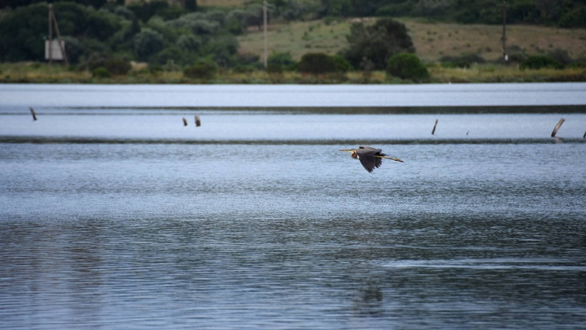
Palionis Lagoon
The Palionis lagoon is included in the Natura 2000 network and is part of the Amvrakikos Gulf wetland. It is classified as an area of outstanding natural beauty. It has a rich flora, fauna and especially avifauna.
The landscape impresses with its serenity. On the banks there are reed beds, while elsewhere the tamarisk trees predominate, which blush in autumn, giving the landscape a special beauty. The lagoon is separated from the sea by a wide strip of sand dunes, where many species of sandy plants grow. On this strip of land there are five windmills abandoned or with inappropriate restoration work.
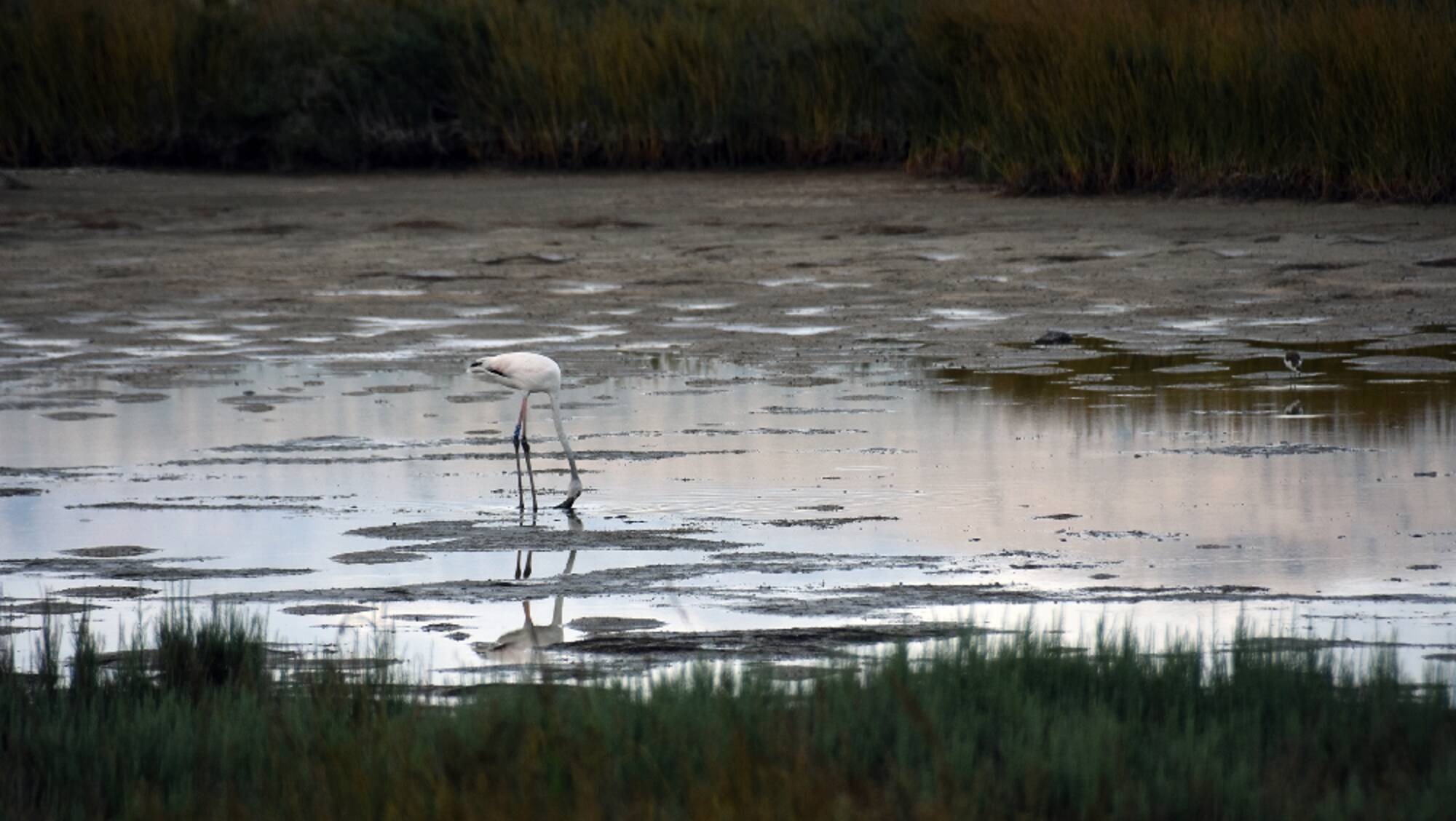
In the water, due to the special conditions, there is a wide variety of snails, crabs, shrimps and fish, some of which live only in the lagoon. The birdlife is also of great importance: Sea crows, chickadees, herons, gulls, gulls, bald eagles, ducks, swans and flamingos bring the area to life.
The old Venetian fortress dominates the northeastern end of the lagoon.
Fortress of Agia Mavra
At the entrance of the town of Lefkada, at the edge of the small strait formed between Lefkada and the opposite coast of Aitoloakarnania, is the medieval castle of the town, built by the Venetian Orsini at the beginning of the 14th century.
The castle, surrounded by a moat, has an area of 25,000 square metres. It took its size and form after a series of modifications from the Venetian to the English times. It has three defensive lines, seven bastions and fires. Today it is only accessible from the western gate. Several ruins of buildings, mainly from the Venetian period, are preserved. The water supply and rainwater drainage system, traces of which can still be seen, is impressive.
In the northern sector are the ruins of the Church of the Pantokratoras, built by Morosini on the site of the mosque when he conquered the castle in 1684, buildings from the English occupation, an English cemetery and the eastern gate with the suspension bridge.
The castle takes its name from the chapel of Agia Mavra built in 1883 and celebrated every year on the 3rd of May, attracting crowds of pilgrims. This church gave its name to the island of Lefkada for a long period of history.
Location
Lefkada
Trekking route
Coordinates
38.84786607 - 20.69816755
High in Exogi
High in Exogi: Exogi - Monastiri Panagias Eleousis - Mountain tour - Exogi
The walker’s/tourist's orientation and safety is solely their responsibility. The present report, the relevant tracks (gpx) and the rest of the informational material are just supplementary. The proper equipment is necessary, depending on the weather conditions and the nature of the route.
Route’s type: circular
Route’s duration: 2 hours and 30 minutes
Route’s length: 6.300m
Level of difficulty: difficult
Suggested season: spring
The route
This route can be accomplished in two ways: a) from the beginning, the whole route to be accomplished on foot , b) from the beginning of the route up until the monastery of Panagia Eleousis (antennas) by car and then downhill on foot. In the second case, we have to pay attention in order to ensure that the car is at the end of the route (at the junction of the path with the asphalt road below the settlement).
The route starts on medium quality asphalt, uphill, through dense vegetation. In case of driving a vehicle, it requires increased caution. In the village of Exogi there are old traditional houses, while the churches of Evangelismos and the Church of Isodia of Theotokos (the Presentation of the Virgin Mary) stand out. After the village, the quality of the road deteriorates and becomes more uphill. The view on the top rewards the visitor (although the necessary antennas are disturbing). The visitor can see in all directions from Kefalonia to the mountains of Central Greece and the islands of the Ionian Sea, while the whole of northern Ithaca unfolds in front of them. Duhera, Afales, Platrithias, Stavros, Frikes are just some of the places that he or she can see from above.
From the monastery, the route goes downhill on a very rough path that can be characterized more as a mountaineering path than as a hiking path. The trail starts outside the monastery (behind the cistern) under the antennas. The signage is faded and needs attention. The walker must take care not to miss the dense markings that are located in the path. The view remains breathtaking. Increased caution on the trail is required. In the middle of the descent, the walker comes across the ruins of an old threshing floor while he or she has a spectacular view of Fiskardo and the rest of Kefalonia. The beach of Ammoudi at our feet is low and sparkling. There are no shady places on the route, so far.
Then the path becomes smoother and slowly improves and from some point, onwards, the path leads through a beautiful forest. The trail needs attention here too, because the recent bad weather (Ιanos) has brought down several trees that disturbed the trail and it is easy for the hiker to become disoriented. After the forest, the hiker has a view of the Stavros and Polis bay. The trail now becomes smooth through shady vegetation.
The duration of the hike from Pernarakia (including local difficulties), without counting any stops, is at least one and a half hour up until the central asphalt road. If the walker does the entire route on foot, he or she should expect to walk for about three hours (on average) because of the uphill nature of the route and the local difficulties. The recommended season is spring because a large part of the route is not shady and it is exposed to the wind.
In Ithaca there are: A Medical Centre in Vathi and a Regional Medical officein Stavros, a Police Station in Vathi and a Citizen Service Centre (KEP) also in Vathi.
Exogi
Exogi is a mountainous settlement of Ithaca, built at an altitude of 340 meters from the sea, which is why its name means "Out of the Earth"! Its small houses are built on the hillside, one above the other. Exogi is one of the oldest settlements of Ithaca. It was founded by the Venetians at the beginning of the sixteenth century and it was the third most important settlement of Ithaca, because of its amazing view and the security it offered from the pirates. Today it has few inhabitants, but in the middle of the 18th century it had 1,400 inhabitants.
Around the village, the land had been formed with berms and it used to produce raisins, olive oil, wine, flax, products which were exported from the port of Frikes. The village's patron saint is Agia Marina (Saint Marina) with the characteristic blue dome and the traditional festival on 17 July. On some house doorsteps in Exogi there is a strange mask, like a carnival mask. It is the "Moros", the mask that was placed there to guard the house from evil spirits.
Monastery of Panagia Eleousa
At a distance of 2 km from the settlement of Exogi, at the top of the mountain, at the location "Pernarakia", the old monastery of Panagia Eleousa is built. Next to the church there are a cell and a bell tower. The monastery is old and it was built at least in the 17th century. It is reported that it had been functioning until the First World War. Afterwards, the care and renovation of the monastery was undertaken by hieromonk Iakovos Mavrokefalos, abbot (1919-1944) of I. M. Romvos Aet/nia, as he intended to retire there. However, he was executed by the German conquerors in 1944 and today his grave is in the monastery's precinct. The Virgin Mary in Pernarakia is celebrated on Easter Tuesday.
Polis beach (Archaeological site-cave)
Polis beach with its green waters and pebbles is located below Stavros, the main village of northern Ithaca. The slopes that surround the bay are covered with cypresses and holly trees. The name of the beach of Polis comes from the ancient city which, according to tradition, lies submerged in the waters of the bay. According to a report by Alexia Komneni, the city of 'Jerusalem', which was located here, was submerged by a great earthquake in 967 AD.
In the northwest of the bay of Polis, there is the Cave of Loizos. In the 19th century, it used to belong to S. Loizos, from whom it took its name. Loizos, while digging there to open a furnace, accidentally found important findings of great historical value. The shells of the vessels, which were found in large numbers, prove that the cave was used as a place of worship, at least from the Mycenaean period up until Roman times. Among the archaeological finds of the cave is the famous shell with the inscription 'EYHEN ODYCCEI'. The cave was destroyed by the 1953 earthquakes and it is not open to visitors today. All the findings are currently housed in the Archaeological Collection of Stavros.
During the route, the walker will encounter QR information signs at the following points: a) the start of the route (on the asphalt road at the junction of the path), b) in Exogi (at the church of the Isodia of Theotokos), c) at the monastery of Panagia Eleousis (Pernarakia), d) at the old threshing floor, e) at the stable.
In Othoni
The route
Othoni, provides a dense network of paths of all kinds, paved, cobbled streets, concrete, earthy, etc., which leads to all of the parts of the island and the beaches. In combination with the low traffic, their rich nature and the low altitudes, it is an ideal place for hiking. Therefore, each walker can configure his own route as he wishes. In this sense, the presented route is indicative.
The route starts from the coastal road of Ammos, which turns north - northwest, where after about 150 meters the path that leads us to Stavros begins. The trail is gently uphill in a lush environment, easily visible and there are informative wooden signs.
Going uphill, we see the view from the whole island, while on our right hand is the area of Argyratika, not long after Pagalatika. Shortly after we meet the road, which we follow for about 90 meters, we find the path again where Stavros is less than 500 meters away. From Stavros, if we wish, we proceed towards Daphne and/or Chorio, otherwise we head east along the road to Damaskatika. Following the quiet road we will meet a junction on our left hand towards the beautiful beach of Fiki (the beach is about 1,500 meters from the junction and the way back is somehow uphill - altitude difference of 150 meters).
From Damaskatika, we descend south towards Ammos and the port. The path is actually a narrow concrete road that is mostly downhill. The walker will encounter several intersections before reaching the beach, so following the route requires attention.
The island has a Regional Medical office and a Police Station.
Othoni
Othoni is located at the westernmost point of the country. It is the largest of the Diapontic Islands, located north of Corfu and belonging to the Ionian Islands Region. It has 393 inhabitants (2011) and it is divided into 2 areas (Ano and Kato Panda).
The first name of the island according to ancient texts (Hesychius, 3rd century BC) was Othronos. It was also called Fidonisi, because of the many snakes it had, and Phanos, because of its lighthouse. According to mythology, in ancient times it was Ogygia, the island of the nymph Calypso. Odysseus fell in love with her and stayed with her for seven years.
The island was conquered by the Franks (in the 11th century) and the Venetians (in the 12th century), while, at the same time, it was often attacked by pirates. In 1537, the famous pirate Hayreddin Barbarossa massacred the island's inhabitants. According to tradition, the event is commemorated by the white stone cross of 1833 on the Kalodiki hill. In 1815, the English conquered the Othonians. With the treaty signed in 1864, the Ionian Islands - and with them the Diapontia Islands - passed permanently to Greek sovereignty.
In the west of the island, near the beach of Aspri Ammos (access is available only through private boats), there is the Cave of Kalypso, 100m long, 10m wide and 20m high and the old churches of Agia Triada (late 17th century), Panagia (17th century), Agios Georgios and Agia Paraskevi. At the northeastern edge, at cape Kastri, at the top of the hill at an altitude of 100m, near the ruins of the venetian fortress, there is the lighthouse of the island. It was built in 1872, it is 13m high and it is the first lighthouse that those sailing from the north to the Ionian Sea encounter.
The main occupations of the current inhabitants are tourism, fishing and olive oil production. The island is full of olive trees which produce the olive oil, with a high content of high quality oil. Most of them are over 300-400 years old and more than seven metres high. There are also cypress trees on almost all the mountain slopes and many fruit trees. The tall mulberry (or Skamnia) and fig (or Skeria) trees are found in almost all the districts and gardens. Oregano, sage and many other herbs thrive. There are also several rabbits and wild rabbits. The common form of reptile is a kind of viper.
Othoni is one of the first stations of migratory birds in southeastern Europe from Libya, especially of warblers. Among marine mammals: the bottlenose dolphin and at least three species of sharks (including the well-known great white shark) have been observed, while occasionally, near the cave of Kalypso, movements of monachus monachus mediterranean monk seal are also observed. The zooplankton in the small bays of the island and especially in Fiki is so abundant that at night, when there is tranquility, it literally illuminates the seabed.
The local festival takes place on 15 August, on the feast of Panagia.
Diapontia Island Complex
Diapontia is a small island complex situated at the north-westernmost part of Greece, in the NE Ionian Sea. The complex consists of three main (populated) islands (Othonoi, Erikousa and Mathraki) and some
smaller uninhabited rocky islets (Trachia, Platia, Diaplo, Diakopo). This fully marine site extends at depths of 0-50 m and covers an area of 153.38 km2. This marine area is characterized by the existence
of Posidonia beds, mainly in depths between 5-30m.
Location
Trekking route
Coordinates
39.85137268 - 19.39507484
.JPG)
Mt. Ainos, Mt. Agia Dynati and Mt. Kalon Oros
Kefalonia is the biggest island in the Ionian region and Mt. Ainos is the highest Ionian mountain with an altitude exceeding 1,600 m. It is a well known mountain, not only due to its altitude but also due to the presence of the famous Abies cephalonica forest which is the main element of the vegetation cover in the highest altitude of this mountain. Abies cephalonica is a Greek endemic species and Mt. Ainos is its "locus classicus". The area of this site consists of three main habitats as follows: a) The Abies forest, very often at moderate altitudes mixed with species of macchie vegetation; b) the rocky slopes which are characterized by looser vegetation but with only a few very important species, and c) the rocky summit and unforested area which houses most of the endemic species of the Kefalonian and Ionian flora. The area of the site has been characterized as a National Park. From a geological point of view, limestones and dolomites constitute the bedrock of Mt. Kalon Oros. The slopes of south and southwest exposure have steep gradients whilst all other slopes are characterized by gentle gradients. The vegetation cover presents a low diversity since it is mainly composed of macchia with the dominant species of Quercus coccifera, Pistacia lentiscus and Arbutus unedo. Macchia vegetation is very dense on eastern and northern exposed slopes, while on the south and southwestern slopes it is very sparse. In higher altitudes up to the peak, rocky grasslands with sparse individuals of Quercus coccifera occur on the west exposed slopes. These areas were cultivated in the past (olive trees, vineyards) but are now abandoned. Source: Natura2000 viewer, European Comission.
Location
Kefalonia Island
Trekking route
Coordinates
0 - 0
Costal Marine Area from Argostoli gulf to Mounta Bay
Marine reptiles: The site includes the coastal marine area (up to the 50m isobath) from the entrance of Argostoli Gulf until Mounta Bay to the south-easternmost point of the island. It also includes the beach and the dunes of Mounta beach. Marine habitats (subregion: PARAKTIA THALASSIA ZONI APO ARGOSTOLI EOS ORMO MOUNTA): In 2015, the site was extended to include the marine area between Vlachata and Mounta bay, where numerous caves, shallow reefs and extensive Posidonia beds occur. The area was also extended 2nm off coast to comprise ecologically important and vulnerable rhodolith beds and coralligenous formations. Source: Natura2000 viewer, European Comission.
Location
Kefalonia Island
Coordinates
0 - 0
.jpeg)
Mon Repos Trecking route
undefined
Location
Trekking route
Coordinates
39.60693602 - 19.92536166
In the historic salt pans
In the historic salt pans: In Alexandros Salt Pans (Kariotes)
The walker’s orientation and safety is solely their responsibility. The present report, the relevant tracks (gpx) and the rest of the informational material are just supplementary. The proper equipment is necessary, depending on the weather conditions and the nature of the route.
Route’s type: linear (the start point is the same as the end point)
Route’s duration: 40 minutes (oneway)
Route’s length: 2,600 metres (oneway)
Level of difficulty: easy
Suggested season: All seasons, weather permitting. In summer, you should avoid the midday hours because there are no shady places along most of the route.
The route
A gentle flat route in the special landscape and surrounding area of the salt marshes and the eastern lagoon of Lefkada with its scattered fortifications. The route starts from the Provincial Road of Lefkada - Vasiliki at the settlement of Karyotes. At the start of the route there is a bus stop and an information sign pointing to "Drepano bay" in Latin characters. Also on the provincial road there are, from both directions, brown information signs pointing to 'Alexandros Alykes'.
We follow the small asphalt road to the east where after about 200 metres we reach the shores of the salt pans. We continue for another 200 metres in the shady surroundings of eucalyptus trees and we change direction to the east, always next to the salt marshes. At this point and on the sea side (south) is the beautiful and unique beach of Karyotes. In about 250 meters we meet the chapel of Agios Panteleimon, which basically marks the end of the shady path.
From this point, and especially from the point where the "tongue" that separates the salt marshes from the lagoon narrows (where there are some ruins of stone-built houses), the landscape has changed dramatically. On the one hand, we have the salt marshes and on the other the fortified lagoon with the castles located on the small islets of Forti and Fortino (the smallest to the north), while on the opposite side the castle of Agios Georgios dominates. Right in front of us, the sailing boats pass quietly by, while on the side of the salt marshes the birds have set up their own fair. This special landscape is marred by the necessary high-voltage electricity poles, but they also add their own touch to its peculiarity.
We continue on our way to the end of the tongue, here it should be mentioned that there is no way to get to the opposite side and complete our route in a circle, and therefore we return by the same route.
The route can also be done by car and is therefore suitable for disabled people. It is also suitable for cycling.
On the island of Lefkada there are:
Citizen Service Centres in the town of Lefkada, in Nydri and in Vasiliki.
Police Headquarters in the town of Lefkada and a Police Station in Vlyho.
In addition to private health structures there are: Hospital in Lefkada Town, Health Centre in Vasiliki and Regional Medical Centre in Syvros.
Alexander Salt Pans
Alexander Salt pans in Karyotes began their operation in the 17th century, south of the old salt pans of the city and near the port Drepano. They stopped producing salt in the late 1980s. In 1993 the Ministry of Culture, recognising their cultural and historical value, declared the salt pans and the accompanying fortifications Alexandros and Konstantinos a listed monument. It is now a Protected Industrial Museum and part of the Natura 2000 Network.
The latter is perfectly understandable, and necessary, since the salt marshes area remains to be an area of rich avifauna and flora even today. The industrial museum, is non-existent, since everything is now in ruins, except for the natural salt pans and two restored buildings.
Salt used to be one of the main export products of the island. The first to organize the regular production of salt in Lefkada were the Frankish rulers of the island, Charles I Tokkos and his wife, Frangiska Atzagioli. Salt was one of the most profitable commodities at that time. The first mention of salt being loaded from the port of Lefkada onto ships from Ragusa was made in 1415. Shortly before that date, the construction of the first salt marshes is estimated to have taken place.
With the conquest of Lefkada by the Venetians in 1684, a larger and more scientific exploitation was carried out with the organization of new salt pans, the Alexandros salt pans, south of the old ones and near the port of Drepano. At the same time the old Frankish saltworks were expanded. In 1948 the operation of the old saltworks was stopped. The buildings were abandoned and deserted and the pans were filled with silt. In 1990 the site of the old salt pans was bazaared and offered for the expansion of the town of Lefkada.
Of the salt produced in Lefkada, most of it was transported to the warehouses of the monopoly in Venice or Corfu, while a part of it remained in the warehouses of the salt works to be sold for the needs of the inhabitants of Lefkada, Preveza, Vonitsa and Kefalonia.
The working conditions during the period when the salt works last operated were harsh. The majority of them were women working from morning till night, often barefoot, carrying the salt on their heads.
Karyotes
Only 4 km from the town of Lefkada is the settlement of Karyotes with its salt pans, surrounded by dense vegetation and next to the stunning beaches of the eastern side of the island. The old village was abandoned, due to landslides, and the current one is a modern settlement, with a modern layout and plenty of greenery. Karyotes is located in front of the historic hill of Koulmos, on which there are ruins of the acropolis of the ancient city of Nirikos.
Forti
Near the village of Karyotes in Lefkada, there are two almost unknown islands, Forti and Fortino. Forti, before it was cut off at the beginning of the 20th century, was the tip of the peninsula of Nea Alykes.
There used to be a small fort there, called Alexandros, but it is better known as Touri or Toreta, meaning Little Tower. The fortress had existed since the Venetian period and was particularly important for the protection of the island, due to its location at the entrance to the strait of Lefkada. It was named Alexandros, in honour of the Russian Tsar, when the Russians renovated it in 1807, to protect the island from Ali Pasha's expansionist plans.
Fortino
Fortino is a small island, just north of Forti. Here, there is also a small Venetian fort, which covers the whole island, and served as a lighthouse and outpost. The chain was attached to it, which, in case of emergency, closed the southern entrance to the lagoon of Lefkada.
As in the neighbouring Forty, the fort was rebuilt in 1804 by the Russians, who gave it the name "Konstantinos" in honour of the then Tsar's surrogate, Alexander. In Roman times there was a bridge here, which connected the island with the opposite mainland of Akarnania.
Location
Lefkada
Trekking route
Coordinates
38.81316188 - 20.72212458
On the two beaches
On the two beaches: Afionas - Porto Timoni - Afionas
The walker’s orientation and safety is solely their responsibility. The present report, the relevant tracks (gpx) and the rest of the informational material are just supplementary. The proper equipment is necessary, depending on the weather conditions and the nature of the route.
Route’s type: mixed (but the starting and the ending point are the same)
Route’s duration: 1 hour and 20 minutes
Route’s length: 3.200 metres
Level of difficulty: difficult
Suggested season: all seasons, if weather conditions permit it
The route
This is a very popular route especially in the summer on a very scenic and interesting route at cape Arilla (or Mourgi). The route starts from the central square of the settlement (next to the Church of Agios Ioannis the Baptist) where it is advisable to have planned to park far away from there (or in the organised parking areas that exist) to avoid possible congestion (especially during the summer months).
Following the paved cobbled street of the settlement we reach an excellent view of the Ionian Sea with scattered islands, islets and rocky islets. In front of us and in the back, there is the island of Othona, a little further ahead is Mathraki, while in the foreground are the islands and islets (from south to north): Gravia (or Kravia), Sikia, Gineka, Karavi, Diakopo, Diaplo. The location also offers an excellent view of the sunset.
We continue south along a beautiful path which requires extra attention because as time goes by it becomes more and more downhill and rough. After an about 600 metres descent, we reach the viewpoint of the double bay of Timoni with its homonymous isthmus. The view from this point is outstanding but requires special attention due to the cliff in front of us and the lack of protection measures. We continue our descent to the beaches where the blue waters reward us for the difficult descent.
The route continues south, slightly uphill, towards the beautiful chapel of Agios Stylianos, which is located inside a cave. We return to the beaches by the same path. Then the strenuous ascent that will return us to the settlement can be done either by the same route, or follow the east-northeast crossing towards the eastern part of the settlement with a very beautiful view of the bay of Agios Georgios and the opposing mountains of Corfu. This second route is less strenuous.
On the island of Corfu there are:
Citizen Service Centres in the settlements (from north to south): Sidari, Acharavi, Kassiopi, Ypsos, Paleokastritsa, Corfu Town, Achilleion, Moraitika, Argyrades and Lefkimmi.
Police stations in the settlements (from north to south): Karousades, Paleokastritsa, Corfu Town and Lefkimmi.
Numerous private medical offices, medical centres and pharmacies, while public health structures exist (from north to south): Avliotes Regional Medical Centre, Acharavi Regional Medical Centre, Agios Athanasios Health Centre, Hospital and Emergency Centre in Corfu Town, Lefkimi Health Centre.
Afionas
Afionas is built on a mountainous cape in northwestern Corfu and it is located 37 km from Corfu Town. It overlooks the open sea, the rocky islet of Gravia, the Diaponitic Islands and offers unique sunsets. From the right of Afionas we can see the bay of Arillas and from the left the bay of Agios Georgios. It is an old, beautiful settlement with old mansions, colourful houses and stone cobbled streets (cantunia). According to tradition, it owes its name to the local variety of grapes called aphioni, which thrives only in Corfu.
The parish church of the village is Agios Ioannis Lampataris, built in 1636. On June 24, the festival of Agios Ioannis is held, while on the eve of the feast the "Lampata", the custom in which fires are jumped, takes place. Next to the church there is a monument in honour of Ektoras Yialopsos. Ektoras Yialopsos was originally from Afiona and was a naval officer who lost his life in Imia in 1996.
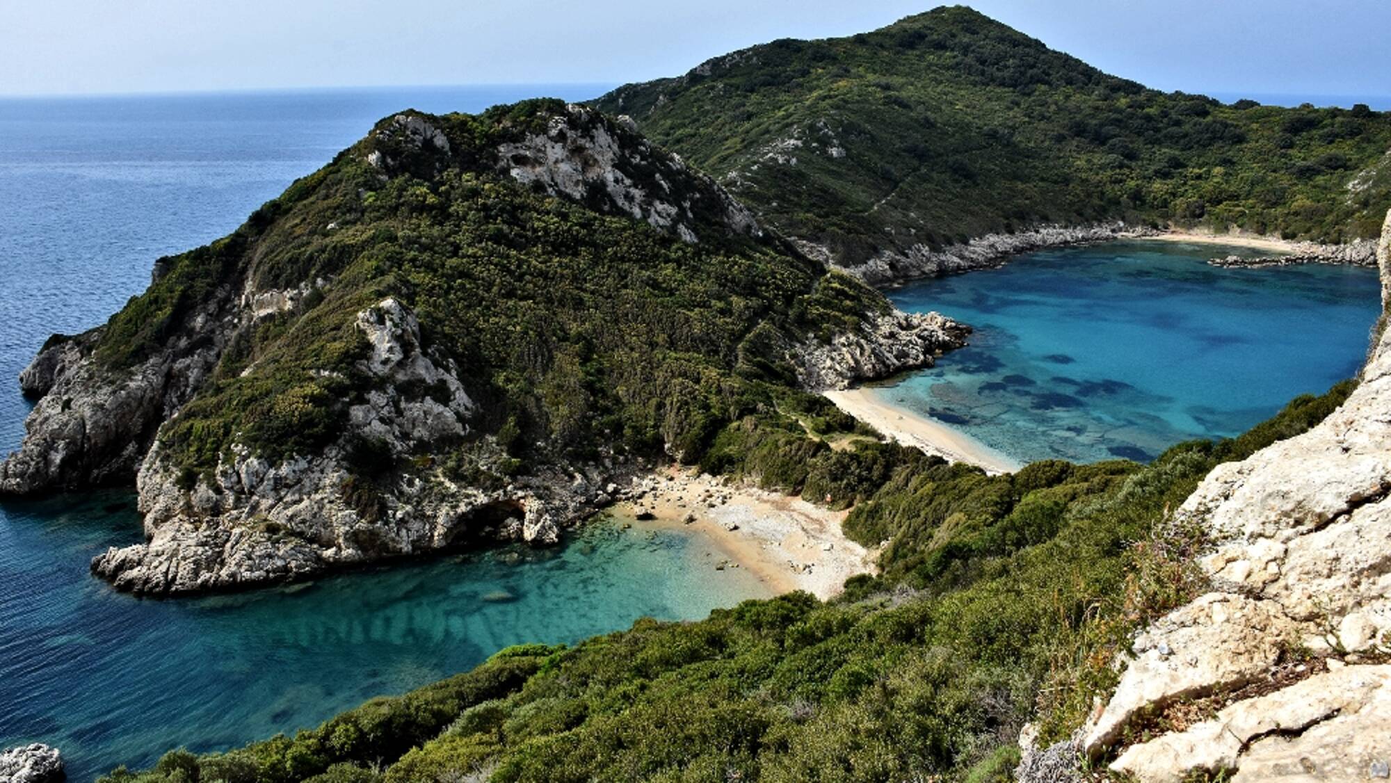
Porto Timoni Beaches
Below Afiona is the famous double beach Porto Timoni. These are two beaches, separated by a narrow strip of land. The eastern one (the one towards the bay of Agios Georgios) is called Limni and has blue waters, while the other (west towards the Ionian Sea) is Porto Timoni with darker waters. The landscape with the double beach is truly beautiful. On your way you will also
Agios Stylianos
After the double beach Porto Timoni and towards the end of the cape, there is Akra Arillas, as it was called in ancient times, or "Head of Mourgi" for the locals, which is actually the chapel of Agios Stylianos carved in a cave. It is a tiny "shelter" for the icon of the saint that gave it its name. According to the legend, a shepherd discovered it in this place among the branches and it was there that the villagers decided to keep it because although the shepherd had tried to place it in the village church, the icon returned back without anyone having taken it. A Neolithic settlement of the 2nd millennium BC has been discovered in the area, the findings of which are exhibited in the Archaeological Museum of Corfu.
The islets of Gravia (or Kravia), Sykia, Gynaika, Diakopo or Diaplo, Karavi, Lipso, Plaka.
Gravia or Kravia, Sykia and Gynaika, are three rocky and uninhabited islands, in front of the bay of Arillas, with rich bushy vegetation and a beautiful seabed, either for diving or for a swim with a mask. They are three of the rocky islets that are part of the complex of the Diapontia Islands and are located north, between Corfu and Mathraki.
In Gravia there is a pebbly beach with crystal clear waters, for those who have a boat and can get there or for those who want to rent a boat from Arillas. There are also a few wild goats living on Gravia, which will not approach you.
Diaplo is also a small uninhabited rocky islet northwest of Corfu that belongs to the complex of the Diapontia Islands and it also belongs administratively to Mathraki. It is an elongated islet with steep, rocky shores. It has crystal clear, turquoise waters and an interesting seabed. It has lush vegetation with low bushes and several animals nest on its shores, such as hares, seagulls and sea crows. In the past there used to be several donkeys, too. In the centre of Diaplos is the chapel of Ai-Nikolas, a unique building of the island. According to mythology, the rocky islets near Diaplo, Karavi, Lipso and Plaka represented the ship, the boat and the anchor of the pirates who landed on the island to plunder it, but were martyred by Ai-Nikolas.
Location
Corfu Island
Trekking route
Coordinates
39.71466034 - 19.65790843